
The Illusion of Certainty
Modern navigation delivers a level of positional accuracy that previous generations could not have imagined. A vessel’s position, course, and speed are continuously available, precise to meters and synchronized across every system on the bridge. That precision has quietly changed maritime behavior. Position is no longer something that is verified, it is something that is accepted.
On a contemporary bridge, GNSS (Global Navigation Satellite Systems) does not operate as one input among many. It defines the reference against which all other inputs are interpreted. ECDIS, AIS, radar overlays, and track control systems align around it, creating a single, coherent picture of reality. The failure mode is subtle: the entire bridge remains internally consistent while the underlying position may not be.
There is no alarm for misplaced confidence.
The Fragility of GNSS-Dependent Navigation
The merchant fleet’s vulnerability is rooted in systemic dependence. In engineering terms, the modern bridge operates with a common-mode failure risk. Most critical systems draw positioning and timing from a single GNSS input. AIS, ECDIS, and communication systems rely on the same reference. A compromised signal does propagates across the entire navigational stack.

The “Slow Walk” and Meaconing or Carry-Off Spoofing
The primary threat is signal manipulation.
Through meaconing, valid GNSS signals are rebroadcast with a controlled delay. The signal structure remains intact while timing is altered, producing a gradual positional shift often described as a “Slow Walk.”
The vessel’s calculated position drifts from its actual position at a rate that may remain within normal operational tolerances, allowing cross-track error alarms to remain inactive while autopilot continues to follow the false track.
A detailed breakdown of GPS spoofing is available here: https://thedeepdraft.com/2018/02/09/gps-spoofing/
This pattern has already been observed in operational waters, including the Strait of Hormuz, where vessels have reported stable but incorrect positions during interference events. Detailed analysis:
The “Circle of Trust” and Data Integrity
GNSS provides both position and precision timing. The vessel’s master clock synchronizes ECDIS logs, AIS transmissions, engine records, and the Voyage Data Recorder. When the GNSS reference is compromised, both position and time are affected, and recorded data may no longer align in sequence or location. In an incident, this affects the integrity of evidence and complicates reconstruction and analysis.
What an Inertial Navigation System Is & What It Is Not
An Inertial Navigation System (INS) is a self-contained navigation aid that provides position, orientation, and velocity without relying on external signals. It operates on the principle of dead reckoning, continuously calculating position based on the vessel’s movement from a known starting point.
At its core is an Inertial Measurement Unit (IMU), comprising:
- Accelerometers to measure linear motion
- Gyroscopes to measure rotation and heading
By integrating acceleration to derive velocity, and velocity to derive position, the system determines where the vessel is based on how it has moved, continuing to provide a position solution regardless of jamming, interference, or signal loss.
For a quick understanding of inertial navigation system, watch –
The Reality of Drift
The primary constraint of INS is drift. Small sensor errors accumulate over time, creating a gradual deviation between calculated and actual position. INS does not deliver permanent positional accuracy. It delivers continuity and independence, which is precisely its value when external signal integrity is in doubt.

Aviation and Naval Baseline vs Merchant Reality
The merchant fleet is an outlier in its dependence on external navigation signals.
Aviation
Inertial Reference Systems are standard on commercial aircraft. GNSS is used as an aiding source to correct drift, while the inertial system remains a primary reference within the flight management system. Navigation is structured around continuous cross-verification.
Naval Operations
Naval vessels are designed for denied environments. They utilize multiple navigation layers, including high-grade inertial systems and warship-adapted ECDIS, assuming that primary signals may be degraded or manipulated.
Merchant Fleet
Commercial shipping is designed for cost-efficiency and operational continuity. GNSS availability is treated as a given, and bridge systems are structured around that assumption.
Independent verification exists in principle, but most decisions are made within a GNSS-referenced environment.
Aviation and naval operations are designed to validate signals. The merchant bridge is structured around using them.

The Real Value of INS – As Part of PNT Resilience
The industry must move toward Positioning, Navigation, and Timing (PNT) resilience. In this framework, INS is not a replacement for GNSS, but part of a sensor-fusion architecture.
The Referee Logic
Using algorithms like a Kalman filter, a system can compare GNSS and inertial inputs in real time. If the GNSS claims the vessel is moving at 15 knots but the INS detects no corresponding acceleration, the system can trigger a “Position Integrity Alarm”. INS provides the independent reference required to detect compromised signals and maintain continuity during disruptions.
It maintains continuity during disruption and enables detection of compromised signals.

Constraints the Industry Cannot Ignore
The barriers to adoption are economic, human & operational
The Cost–ROI Gap
High-grade INS, such as Fiber Optic Gyros (FOG), involves significant capital cost. For most operators, the benefit is not a continuous gain but avoiding incident exposure, making the commercial case difficult to justify without external pressure.
The Hormuz Paradox: Survival vs Strategy
Critics of Inertial Navigation System adoption often point to current operations in the Strait of Hormuz as evidence of resilience. Vessels transit interference zones daily without inertial backup, maintaining schedules through manual reversion. This is operational survival, not systemic integrity.
The system functions by shifting the burden to the bridge team. When GNSS is compromised, navigation reverts to parallel indexing, radar fixing, and visual bearings. This is a high-workload fallback, not a sustainable operating model.
Current outcomes are also influenced by the nature of interference. Most disruptions are detectable jamming. The greater risk is low-profile spoofing, where position error develops gradually without triggering alarms. Such conditions are not reliably detected through manual methods alone.
This is not resilience. It is exposure managed through effort.
Operational Reality
If GNSS and INS data diverge, current training does not provide the Officer of the Watch (OOW) with a defined hierarchy for decision-making. In practice, crews are likely to follow the familiar, integrated display even when it is incorrect.
When positional integrity is in doubt, the bridge must revert immediately to independent verification through visual bearings, radar fixing, and manual navigation.
The Maintenance Gap
High-precision inertial systems require controlled environments, calibration, and periodic verification. These practices are standard in aviation and naval operations. They are not yet embedded within merchant fleet maintenance structures.

Regulatory Silence and the Insurance Lever
The IMO has acknowledged GNSS interference as an operational risk. There is no current mandate requiring independent positioning systems or resilient navigation architecture on commercial vessels. Regulatory development follows consensus and lags emerging electronic threats.
The Shift to Underwriters
The primary driver of adoption is likely to be insurers. P&I Clubs and underwriters are increasingly assessing navigational integrity for vessels operating in high-risk areas like the Red Sea or Black Sea. If a grounding is linked to compromised positioning, the absence of an independent verification system such as INS becomes relevant to the question of seaworthiness. Insurance conditions often evolve faster than international regulation.
The argument is straightforward: the vessel was not equipped to verify its own position independently.
The Commercial Trigger
Insurance conditions evolve faster than regulation.
Additional premiums, trading restrictions, or equipment-related requirements may emerge for high-risk transits, making independent position verification a commercial expectation before it becomes a formal regulatory one.
The transition is more likely to begin with underwriting conditions than with regulation.

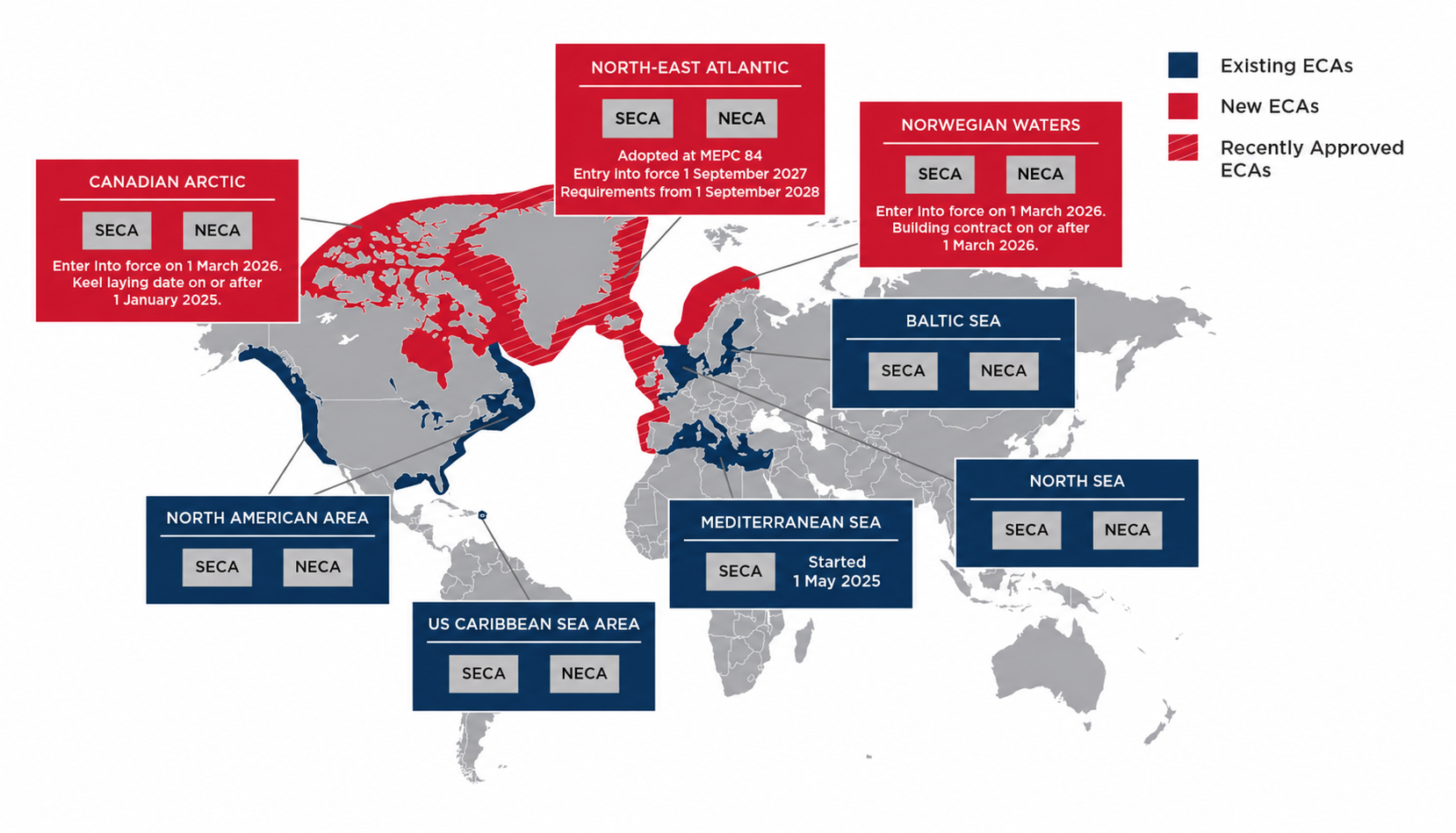
Where INS Adoption Will Actually Begin
Geographic Concentration
High-risk zones are already defined:
- Strait of Hormuz
- Red Sea
- Eastern Mediterranean
- Black Sea
These are environments where spoofing, jamming, or signal degradation are not hypothetical. They are recurring operational conditions. In such areas, the ability to independently verify position moves from being desirable to necessary.
Vessel Profile
Not all vessels carry the same level of exposure.
Early adoption is more likely among:
- Crude and product tankers
- LNG carriers
- Vessels carrying high-value or high-liability cargo
For these segments, a navigational error is not just a safety issue. It is a financial and legal event with significant downstream consequences.

The Autonomous Frontier
Autonomous and semi-autonomous vessels require validated navigation inputs.
Maritime Autonomous Surface Ships (MASS) cannot rely on a single external signal. Navigation decisions must be based on a system that continuously verifies position, motion, and timing across multiple inputs.
INS forms a foundational component of that architecture.

Accuracy to Credibility
Modern navigation has achieved positional accuracy. The requirement now is credibility.
A navigation system must not only provide a position. It must establish that the position is reliable. This requires a bridge architecture built on verification, where external inputs are assessed rather than accepted.
The structure becomes layered: GNSS when validated, INS as an independent reference, and radar or terrestrial fixing as physical verification. Navigation becomes the process of validating the display rather than following it.
The maritime industry is not facing a failure of technology. It is facing a mismatch between bridge design and the environment ships now operate in. GNSS transformed navigation by delivering continuous, precise positioning, but bridge systems evolved around accepting that signal rather than questioning it.
Inertial navigation does not replace GNSS. It restores independence by providing a second reference that is not vulnerable to the same failure mode.
The issue is no longer position accuracy. It is position credibility.
The question is no longer whether GNSS can fail.
The question is whether the industry is prepared to navigate when it does.
Media Section
Sources
INS working principle: classical inertial navigation based on accelerometer and gyroscope measurements integrated over time (dead reckoning), as described in standard references such as Groves, Principles of GNSS, Inertial, and Multisensor Integrated Navigation Systems.


Leave a Reply