The Anchored Silence: Tactical Reality in the Gulf
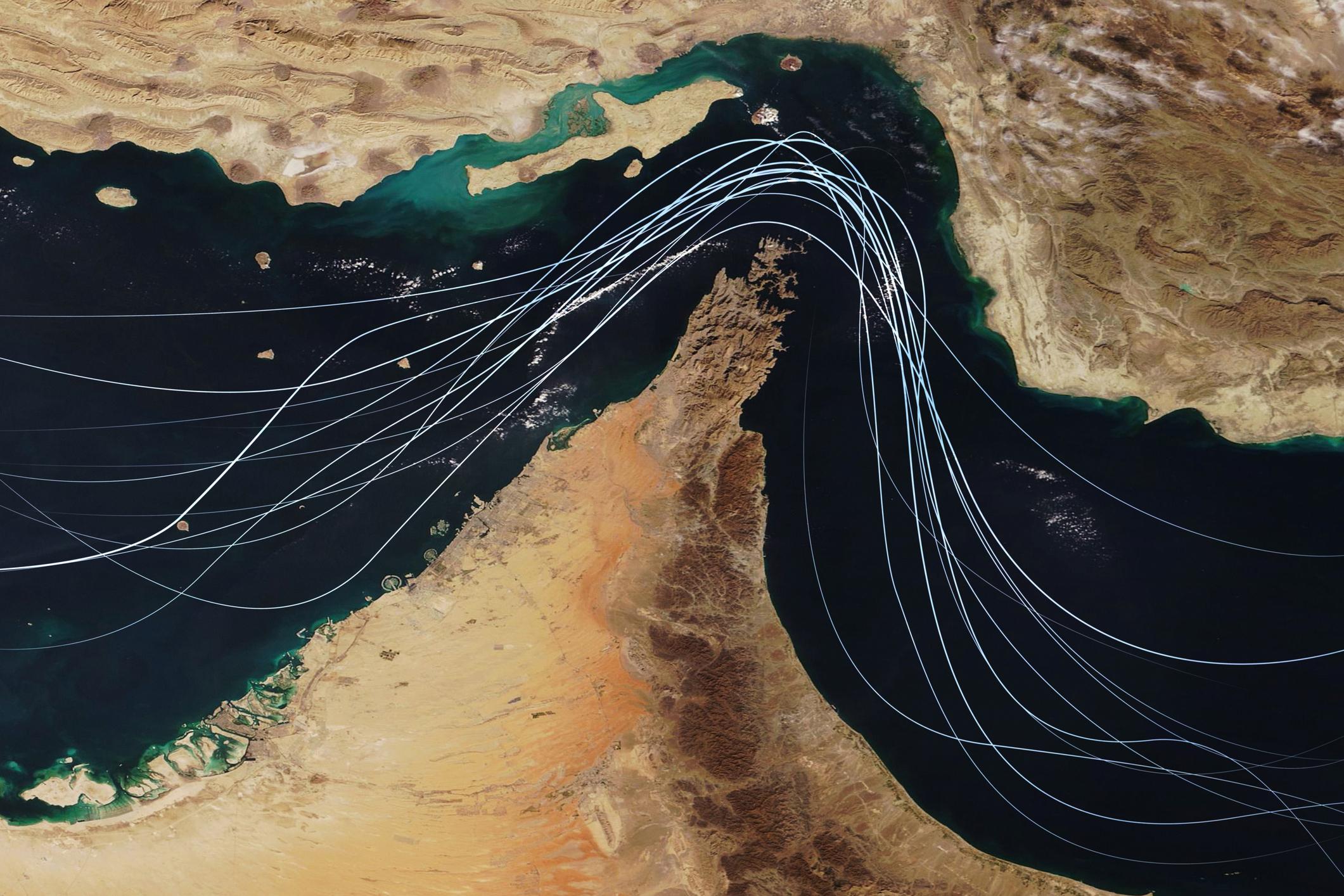
Across Gulf anchorages, merchant tonnage is largely at a standstill. Following recent escalation, transit through the Strait of Hormuz has shifted from routine passage to a high-risk electronic-warfare environment.
While many operators have paused movements, the Indian Navy has moved to safeguard national energy shipments under Operation Sankalp. On 14 March 2026, the Indian-flagged LPG carriers Shivalik and Nanda Devi became the first such vessels in nearly two weeks to cross the Strait under naval escort. The transit was conducted under close protection of an Indian Navy warship as part of heightened maritime security operations in the region.
The operational environment remains unstable. Maritime intelligence reporting indicates more than 1,700 GNSS interference events recorded across the affected area in early 2026. Maritime analytics firm Windward also documented over 1,100 vessels simultaneously spoofed toward inland infrastructure within a 24-hour period.
| Hotspot | Events (Feb–Mar 2026) | Ships Affected | Typical Signature |
| UAE (Dubai / Fujairah) | 925+ Jamming Events | 655+ Vessels | Inland spoofing toward airports |
| Gulf of Oman | 190+ Events | 1,100 Ships (24-hr peak) | AIS circles / position jumps |
| Black Sea | Ongoing | Tankers affected | False AIS positions |
For the Master, the operational question is straightforward: how to maintain situational awareness when the “blue dot” on the ECDIS becomes a potential source of systematic error.
Satellite Navigation on the Modern Bridge
Over the past two decades, satellite navigation has evolved from a standalone sensor into the primary positional input of the Integrated Bridge System (IBS).
Modern receivers typically process multiple satellite constellations including GPS, GLONASS, Galileo and BeiDou, but these systems remain vulnerable to the same forms of radio-frequency interference.
On most modern bridges, ECDIS positioning, radar overlay alignment, and AIS transmissions are all derived from a single GNSS source. Several safety and communication systems including VHF-DSC, GMDSS terminals, Voyage Data Recorders (VDR), and some echo sounders also rely on the same satellite input for time-stamping and geo-referencing.
When GNSS integrity is compromised, the bridge does not simply lose a position; it experiences a digital cascade.
Because these systems share the same GNSS input, AIS, GMDSS, VDR and other bridge equipment may begin reporting corrupted or invalid information simultaneously. What initially appears as multiple equipment failures is usually a single problem: the integrity of the satellite position itself.
In effect, a single spoofing transmitter can compromise not only navigation but also the vessel’s digital record of the voyage.

Jamming and Spoofing
GNSS interference at sea generally appears in two forms: jamming and spoofing. Understanding the difference is critical for bridge team reaction.
Jamming is effectively a denial-of-service attack. High-power radio interference blocks satellite signals, causing receivers to lose satellite lock. The ECDIS and other bridge systems immediately trigger “loss of position” alarms, alerting the bridge team that satellite navigation is unavailable and that backup navigation methods must be used.
Spoofing is more deceptive. Instead of blocking the signal, a transmitter broadcasts false satellite data that imitates legitimate GNSS transmissions. In navigation safety terminology this condition is known as hazardously misleading information, a situation far more dangerous than a complete loss of position.
The operational danger lies in the psychological effect on the Officer of the Watch. Jamming tells the bridge it is navigating blind. Spoofing convinces the bridge it can still see while leading the vessel into danger.
Carry-Off Spoofing
Not all spoofing produces an immediate or obvious position error. In a carry-off attack, the interfering transmitter first synchronizes with the vessel’s genuine GNSS signal and then gradually alters the calculated position. The counterfeit signal is then gradually increased in strength until the receiver begins tracking the false signal instead of the authentic satellite transmission.
Instead of a sudden jump on the electronic chart, the vessel’s reported position begins drifting slowly away from its true geographic location. Because this drift occurs incrementally & often resembling natural tidal movement. Receiver integrity checks such as RAIM (Receiver Autonomous Integrity Monitoring) may not immediately detect the manipulation. Because the track remains smooth and continuous, bridge teams may initially interpret the drift as tidal set rather than navigation system manipulation.

The ECDIS therefore continues plotting a stable and apparently valid track while the vessel’s true position quietly diverges from reality.
Detection in such cases depends entirely on the bridge team’s ability to cross-check independent navigation sensors rather than relying solely on satellite-derived data.
Tactical Threat Table
| Threat | System Behaviour | Detection Indicator | Primary Fallback |
| Jamming | Total signal loss | “Loss of Position” alarms | DR / EP navigation |
| Simple Spoofing | Position jumps | Radar overlay mismatch | Manual radar fixes |
| Carry-Off Spoofing | Gradual positional drift | SOG/STW discrepancy | Radar / Echo Reference |
What Happens Inside ECDIS When GPS Fails
Modern ECDIS systems are designed for graceful degradation rather than complete failure when GNSS input is lost.
When satellite signals fall below integrity thresholds, the system typically switches automatically from GNSS positioning to Dead Reckoning (DR) or Estimated Position (EP) mode.
The last valid satellite fix becomes the reference point from which the system begins projecting the vessel’s movement across the chart using gyro heading and speed log input.If tidal set and drift are applied by the Officer of the Watch, the system calculates an Estimated Position rather than a simple DR.
While this allows navigation displays to remain operational, the calculated position gradually diverges from reality as sensor errors accumulate. Speed log calibration errors, gyro drift, and environmental factors can steadily increase positional uncertainty. The accuracy of this projection therefore depends entirely on the integrity of gyro heading and speed log calibration.
For this reason, once GNSS integrity is lost, independent radar or visual fixes become operationally essential to maintain positional accuracy.

Alarm Cascade on the Bridge
GNSS disruption rarely appears first as a simple navigation error. Instead, it usually manifests as an alarm cascade across multiple bridge systems.
Because many instruments depend on the same satellite input, the bridge team may suddenly face numerous alerts at the same time:
Primary Navigation
ECDIS may report “Loss of Position Input” or “Invalid GNSS”.
Communications Systems
AIS units generate warnings for invalid GPS data, while GMDSS terminals and NAVTEX receivers report position feed errors.
Auxiliary Sensors
Echo sounders and VHF-DSC systems that rely on GNSS for position tagging may also trigger independent alerts.
In restricted waters the primary risk is alarm fatigue. Multiple alarms can create the impression of a widespread equipment failure, causing watchkeepers to focus on troubleshooting digital sensors instead of maintaining situational awareness. The bridge team may therefore spend critical minutes diagnosing alarms rather than verifying the vessel’s position.
In congested traffic environments, this distraction can degrade bridge awareness faster than the navigation error itself. The Master’s standing orders should therefore be clear: acknowledge the alarms, verify the radar picture, and confirm the vessel’s position using independent sensors.

Detecting GNSS Interference
GNSS interference usually becomes visible through inconsistencies between navigation sensors rather than through satellite alarms alone.
Bridge teams should monitor the following indicators:
Radar Overlay Mismatch – Radar coastline returns no longer align with the electronic chart. This is widely regarded as the clearest indicator of spoofing. A sudden displacement of radar coastline by several miles while the GNSS position remains stable is widely recognised as a spoofing signature.
SOG vs STW Discrepancy – A significant unexplained difference between Speed Over Ground and Speed Through Water in steady current conditions may indicate corrupted GNSS data.
HDOP / Position Accuracy Spikes – Sudden increases in satellite accuracy values can indicate degraded signal integrity.
Parallel Index Drift – Parallel index lines begin to diverge from the expected track while the ECDIS position appears normal.
Echo Sounder Mismatch – Measured depth does not correspond with charted depth contours along the planned route.
Several incidents in the Gulf and the Black Sea have shown radar coastlines displaced by 2–3 nautical miles while GNSS positions appeared stable, an unmistakable signature of spoofing.

Navigating Without GNSS
Even without satellite positioning, the bridge team retains several reliable methods for maintaining positional awareness.
Radar Integrity Fixes – Radar ranges and bearings to charted objects provide independent position verification and remain the primary terrestrial reference when GNSS integrity is doubtful.
Echo Reference (ER) Mode – Many modern ECDIS installations, including systems developed by Wärtsilä/Transas, provide an Echo Reference (ER) function. By locking onto a radar-conspicuous object such as a lighthouse, offshore platform, or headland, the system maintains the vessel’s chart position relative to that fixed terrestrial target rather than satellite input.
Manual Fixing – ECDIS allows manual entry of Lines of Position (LOPs) derived from radar or visual observations. Once a reliable fix is obtained, it resets the Dead Reckoning (DR) origin, ensuring the display continues to provide useful tactical guidance. Visual bearings where available remain one of the most reliable independent position references.
Contour Verification – Comparing echo sounder depth readings with charted depth contours provides an additional confirmation of the vessel’s position, particularly in coastal or confined waters.

Navigational Resilience
Modern ships rely heavily on satellite navigation, but in contested waters GNSS integrity can no longer be assumed.
When satellite signals become unreliable, safe navigation depends on the bridge team’s ability to recognise corrupted data and revert to independent navigation sensors such as radar fixes, parallel indexing, and depth verification.
Resilience therefore lies not in the technology itself, but in the discipline of the bridge team. Radar cross-checks, manual position fixing, and continuous sensor verification must remain active parts of watchkeeping rather than forgotten backup skills.
In environments such as the Strait of Hormuz, seamanship is no longer only about handling the ship. It is about sensor management, knowing when navigation systems are reliable and when they are not.
A bridge team that cannot navigate without satellite lock becomes dependent on a single vulnerable system. A team that can verify position using radar, depth contours, and disciplined cross-checking retains command of the vessel even when satellite navigation fails.
Navigational resilience is ultimately the ability to maintain control of the ship when satellite navigation can no longer be trusted.

Media Section
Sources
• International Maritime Organization (IMO), MSC.1/Circ.1575 – Guidelines for Shipborne Position, Navigation and Timing (PNT) Data Processing
• Windward Maritime AI – GNSS Interference and Maritime Navigation Risk Reports
• NATO Shipping Centre – GNSS Interference Navigation Warnings
• U.S. Coast Guard Navigation Center (NAVCEN) – Maritime GNSS Interference Advisories


Leave a Reply