
For decades, IALA buoyage systems provided fixed reference points ie. solid, visible, reliable. Today, navigation extends beyond charts and visuals. Smart and virtual buoys are redefining how bridge teams manage situational awareness, traffic routing, and navigational safety.
Virtual AIS AtoNs are digital markers without a physical counterpart and are increasingly complementing smart buoys, allowing temporary hazards or traffic changes to be marked instantly on ECDIS.
Lessons from the Bridge
A few years ago, I was steering a vessel through a congested pilotage channel when a squall reduced visibility to near zero. Radar clutter made even the physical buoys difficult to pick out. Fortunately, our ECDIS was integrated with AIS AtoN messages from smart buoys in the port approach. In fact, the Port of Rotterdam began deploying these sensor-equipped smart buoys around 2018, transmitting environmental data and route guidance directly into the chart display.
The overlay highlighted the recommended track and a shallow patch. It didn’t replace radar or visual lookouts, but it enhanced confidence and redundancy. Similar integrations exist in practice: NOAA’s CBIBS buoys transmit real-time data into navigation systems, and Singapore’s port VTS systems are trialing AIS AtoN integration with ECDIS.
In parallel, virtual buoys could be deployed from the VTS to supplement or temporarily replace damaged buoys, providing a layered safety net in congested or high-risk areas.

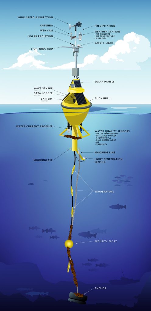
What Are Smart Buoys?
Smart buoys are physical Aids to Navigation (AtoN) enhanced with sensors and communication systems. Their core functions include:
- Environmental monitoring: depth, current, tide, wave height, temperature, salinity.
- Traffic and safety alerts: transmitting AIS AtoN messages to nearby vessels.
- Research & port operations: feeding oceanographic data into shore-based VTS (Vessel Traffic Services).
IALA recognizes AIS AtoN in three forms:
- Type 1 – broadcasts via AIS only (no feedback).
- Type 2 – can receive and transmit, allowing remote configuration.
- Type 3 – fully integrated with multiple sensors (the “smart buoy” setup).
Smart buoys are concentrated in harbors, pilot stations, and critical approaches, where they supplement conventional buoys and enhance VTS coverage.
Virtual AtoNs are increasingly being used alongside these smart buoys to mark temporary hazards, dynamic traffic lanes, or dredging areas, offering flexibility that physical buoys cannot.

ODAS: The Precursor and Partner of Smart Buoys
Long before “smart buoys” existed, Ocean Data Acquisition Systems (ODAS) collected meteorological and oceanographic data. Wind, pressure, sea temperature, wave height, currents and transmitted it to shore via satellite or radio. Originally used for forecasting, climate studies, and safety, ODAS were not classified as navigational aids.
Recent developments added enhanced sensors, hybrid solar-wind power, high-bandwidth satellite/4G/5G communications, and modular designs. Though large and costly, ODAS now complement smart and virtual buoys, providing validated environmental context. Future IoT-enabled ODAS may serve both science and navigation within the wider e-Navigation ecosystem.
By integrating ODAS, smart buoys, and virtual AtoNs, the bridge receives a richer environmental and navigational picture, enhancing both safety and situational awareness.
Integrating Smart Buoy Data with Onboard Navigation Systems
In 2025, real-world implementations such as Singapore’s smart buoy initiative for coastal monitoring and Kyocera’s smart buoy trials demonstrate how these technologies are actively enhancing maritime safety and environmental monitoring. In addition.
Virtual AtoNs, deployed and updated by shore authorities, can be layered onto the same ECDIS system, creating an adaptable “digital chart layer” that complements physical sensors.
Integration follows international standards such as S-100/S-124, enabling reliable incorporation into ECDIS and bridge decision-support systems.
Communication Links: Smart buoy data reaches ships through:
- AIS (Automatic Identification System) – direct broadcast of AtoN messages to the ship’s AIS/ECDIS.
- Satellite (Iridium, Inmarsat) – for offshore buoys, requires shipboard satcom.
- Cellular (4G/5G) – coastal deployments with shore-linked platforms.
- VHF Data Exchange (VDES) & LoRaWAN – emerging methods for higher-bandwidth coastal data exchange.
Onboard Equipment
To utilize this data, ships need:
- AIS transceiver/receiver (mandatory equipment on SOLAS ships).
- ECDIS or integrated bridge system capable of displaying AIS AtoN overlays.
- Satellite or GSM modem (if cloud-based feeds are used).
- Optional IoT gateways for research or specialized vessels.
Workflow Example: A smart buoy detects current shear, transmits AIS Message 21 plus sensor data. The ECDIS displays depth/current overlays. The OOW evaluates alongside radar and echo sounder, informs the Master, and adjusts course.
Takeaway: Smart buoy data integrates seamlessly into existing bridge routines, if properly integrated. Overlaying virtual AtoNs with smart buoy data adds flexibility for temporary hazards, creating a dynamic, adaptive navigation environment.

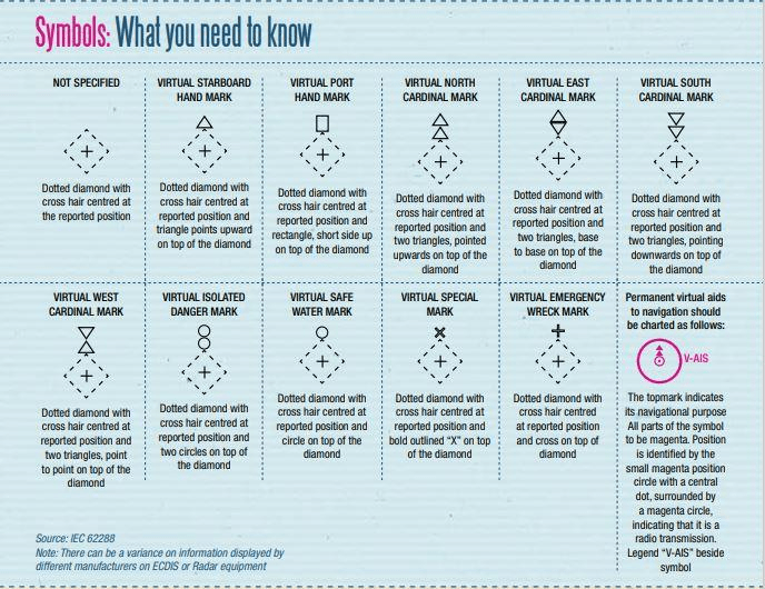
Virtual Buoys: The Invisible Watchmen
Virtual buoys are AIS AtoN objects without a physical structure, shown as symbols on ECDIS or radar overlays. They are used for:
- Marking temporary hazards (wrecks, dredging, drifting objects).
- Defining dynamic traffic separation schemes.
- Supplementing or replacing damaged buoys.
Advantages: Instant deployment, no physical maintenance, integration with real-time smart buoy sensor data. Operators must cross-check positions to avoid over-reliance.
Integration & Redundancy
The real power lies in combining the two:
- Smart buoys deliver environmental awareness.
- Virtual buoys provide flexible, dynamic marking.
Together, they create a layered navigation safety net. But redundancy is key: a prudent navigator still cross-checks with radar ranges, visual bearings, and parallel indexing.
The Nautical Institute emphasizes that combining physical, smart, and virtual AtoNs allows bridge teams to manage risk dynamically, especially in congested or hazard-prone areas.
Challenges Remain
Technology isn’t flawless. As a captain, I remain cautious about:
- System failures or inaccuracies: Sensors can malfunction; digital markers may misalign.
- Cybersecurity threats: Virtual buoys and cloud-based smart buoy data could be targeted. For instance, AIS spoofing attacks can manipulate virtual buoy data, leading vessels off course. Additionally, vulnerabilities in cloud-based systems can expose smart buoy data to unauthorized access or tampering.
- Over-reliance on tech: Nothing replaces experience and intuition. Human oversight remains irreplaceable. A well-trained captain must interpret the data, verify alerts, and maintain traditional navigation skills.
Looking Ahead
The maritime future is exciting:
- Autonomous vessels can leverage smart and virtual buoys for safe, efficient routing
- Global environmental monitoring will improve with widespread smart buoy networks
- Dynamic, hybrid navigation systems may make shipping safer, more efficient, and environmentally responsible
Yet, as someone who has felt the ocean’s unpredictability, I believe technology should enhance & not replace human judgment. Smart and virtual buoys are powerful, transformative tools but the sea always demands respect, vigilance, and experience.
References & Further Reading
References & Further Reading
- Bojic, F., Karin, I., Juričević, I., & Čipčić, M. (2021). Design and Application of an Automated Smart Buoy in Increasing Navigation Safety and Environmental Standards in Ports. TransNav, 15(2).
- IALA (2008). Guideline G1062: Establishment of AIS as an Aid to Navigation. International Association of Marine Aids to Navigation and Lighthouse Authorities.
- NOAA. Chesapeake Bay Interpretive Buoy System (CBIBS). Operational buoy network delivering real-time environmental data for navigation, science, and safety.
- Fraunhofer IGD. ODAS Platform for Intelligent Ocean Monitoring. Research initiative showing how ODAS systems are evolving with modular sensors and IoT integration.
- Satlink (2021). OceanDepth Smart Buoys Project. Use of ODAS-type buoys for bathymetric monitoring and coastal erosion studies.
- Hydro International (2022). Eight Oceanographic Buoys for Newfoundland’s Marine Institute. Highlights expanded ODAS applications in fisheries and marine safety.
- EIVA NaviSuite. Commercial software for deploying, monitoring, and visualizing virtual buoys in offshore and coastal projects.
- Kyocera (2022). Smart-Sensing Buoy Trials. IoT-enabled buoys for ocean monitoring and navigation safety applications.
- Singapore Smart Buoy Initiative (2022). National trial program for coastal monitoring and maritime safety in the Singapore Strait, as reported in The Straits Times.
- Nautical Institute (2023). Virtual Aids to Navigation: Practical Guidance for Mariners. https://www.nautinst.org/resources-page/virtual-aids-to-navigation.html
- Bojic, F., Juričević, I., & Čipčić, M. (2022). Integration of Smart and Virtual AtoNs for Enhanced Navigation Safety. Journal of Navigation Technology.
- IMO (2021). e-Navigation Strategy Implementation Plan (SIP). International Maritime Organization.

Leave a comment